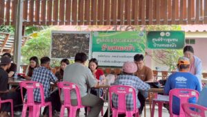
To provide technical support on participatory climate-risk mapping and adaptation planning, the CGIAR Initiative on Asian Mega-Deltas conducted the Climate-Smart Mapping and Adaptation Planning (CS-MAP) Workshop for local research partners in Phnom Penh, Cambodia on 19-20 December 2022. The workshop introduced the CS-MAP approach as the tool for conducting mapping activities in the provinces of Kandal, Takeo, Prey Vieng, and Svay Rieng.
Developed and implemented by the Department of Crop Production of Vietnam and the CGIAR Research Program on Climate Change, Agriculture and Food Security in Southeast Asia, CS-MAP is a participatory approach that integrates local knowledge and science-based research in developing maps of climate-related risks and adaptation plans for crop production, suitable to location-specific conditions. It has been effectively implemented in five ecological regions of Vietnam, including the Mekong River Delta region, to help farmers mitigate climate-related risks, such as flooding, drought, and salinity intrusion.
Raed the story @IRRI


